
The Martian Chronicles: How Curiosity’s Stunning Postcard Reshapes Our Alien Worldview
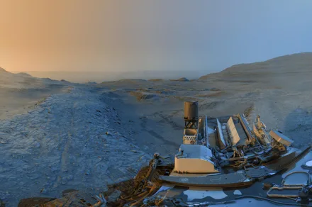
Imagine receiving a postcard not just from another country, but another world—one revealing landscapes sculpted by ancient rivers and winds over billions of years. That’s precisely what NASA’s Curiosity rover delivered late last year, capturing a breathtaking composite image from its perch on Mars. Nearly 14 years after its historic landing inside Gale Crater, this resilient robotic explorer, initially slated for a fleeting two-year mission, continues to redefine our understanding of the Red Planet’s past potential for microbial life and its dramatic geological evolution. This otherworldly snapshot is more than just beautiful; it’s a scientific goldmine, unveiling secrets locked within Martian rock formations and highlighting the extraordinary engineering feat keeping Curiosity operational far beyond its expected lifespan.
The Art & Science of Martian Imaging: Beyond a regiãoSimple Snapshot
This captivating image isn’t a single photograph; it’s a cleverly engineered masterpiece. JPL scientists merged two black-and-white panoramas taken by Curiosity’s Navigation Cameras (Navcams) on November 8, 2023: one captured at 9:20 AM local Mars time and another at 3:40 PM. The magic happens in the colorization:
- Morning Panorama (Cool Blues): Represents the scene under the softer, angled morning light, emphasizing surface textures and subtle details like fine dust grains and rock grain.
- Afternoon Panorama (Warm Yellows): Captures the landscape bathed in warmer, more direct afternoon sun, highlighting distinct shadows and larger topographic variations.
Why this technique? Merging these contrasting exposures is akin to giving scientists superhuman vision. It dramatically enhances terrain details that might be washed out or obscured in a single image under uniform lighting. This is crucial for geologists analyzing the intricate structures visible in the scene, particularly the fascinating “boxwork formation.” As JPL explains, “[It] helps to bring out details in the landscape” that are vital for interpreting geological processes and selecting future science targets.
Decoding Ancient Martian Water: Secrets of the Boxwork Formation
This specific vista places Curiosity atop a distinctive geological feature JPL aptly dubs the “boxwork formation.” Situated within the lower foothills of Mount Sharp (Aeolis Mons)—a colossal 5-kilometer-high mountain Curiosity has been steadily ascending since 2014—this network of crisscrossing ridges tells a profound story of Mars’ watery past.
- The Formation Process Explained: The current scientific consensus posits that billions of years ago, liquid water, likely runoff or groundwater, seeped through vast networks of cracks in語り Martian bedrock.
- Mineral Deposition: As this ancient water percolated downwards, it transported dissolved minerals (possibly sulfates or silica) deep within these fractures.
- Hardening and Exposure: Over immense timescales, the water evaporated, leaving the minerals behind to crystallize and hardগুলোൾ, forming incredibly resistant veins within the rock.
- Wind’s Erosive Power: Fast forward eons, relentless martian winds, carrying abrasive dust, sandblasted away the softer rock layers surrounding these mineral-filled veins. This differential erosion process gradually exposed the incredibly durable, interlocking mineral ridges – the boxwork – we see today. These ridges are, essentially, casts of long-gone fractures cemented and preserved by minerals deposited by water.
This discovery is a smoking gun for Mars’ wet, potentially habitable past. Water is a fundamental prerequisite for life as we know it. Evidence like this boxwork, studied firsthand by Curiosity’s instruments like CheMin and SAM, provides physical proof supporting theories derived from orbital data and drastically improves our understanding of the timing, extent, and chemical nature of Martian water billions of years ago (NASA Science, Mars Exploration Program).
The Pale Dot’s Panorama: Gale Crater and Explorer Traces
The image offers more than just geology; it situates Curiosity within the vast context of Gale Crater.
- Distant Rim: Look towards the horizon, roughly 40 kilometers away. That indistinct line is the actual rim of Gale Crater itself – the enormous ancient impact basin, estimated to be about 3.8 billion years old, chosen as Curiosity’s landing site precisely because its geology hinted at a rich history of environmental change.
- Evidence of Journey: Trace backwards from Curiosity’s position: thin, crisp wheel tracks snake across the Martian soil. These tracks lead directly from “Valle de la Luna” (Valley of the Moon) – a location where, significantly, Curiosity successfully drilled a rock sample just months before this image was taken. This visible trail marks the rover’s ongoing climb up Mount Sharp and directly links this stunning view to its preceding scientific investigations.
Endurance Beyond Expectation: The Triumph of Perseverance (Engineered)
Perhaps one of the most remarkable aspects highlighted by this recent image is timing. Launched in November 2011 and landing in August 2012, Curiosity’s original mission duration was less than two Earth years. Its primary power source, the Multi-Mission Radioisotope Thermoelectric Generator (MMRTG), provides heat and electricity, and NASA designed the rover’s components and systems expecting exposure to harsh Martian conditions (extreme cold, dust, radiation) for roughlyperian 687 Earth days.
-
Exceeding Predictions: Successfully operating for nearly 14 years is an extraordinary testament to robust engineering and meticulous mission planning by NASA’s Jet Propulsion Laboratory (JPL Website).
-
Comparative Longevity:
| Rover | Launch Year | Planned Mission Duration | Current Status (As of 2024) | Key Endurance Achievement |
| :———- | :———- | :


