
From Snowbanks to Screens: How Your iPhone Transformed My Blizzard Battle
Did you know the phone in your pocket can instantly measure the height of a massive snowdrift with laser precision? During the historic Blizzard of 2026—dubbed “Bomb Cyclone Hernandez”—I found myself waist-deep in whiteout conditions across the Northeast US, shoveling unrelenting snow. But surprise relief came not from stronger muscles, but from my iPhone 17 Pro Max. In moments needing accurate measurement—whether verifying snowfall totals for frantic meteorologists or assessing back-breaking shovel piles—this pocket device proved indispensable. The iPhone Measure app, coupled with sophisticated hardware, rescued me from needing a yardstick embedded somewhere under several feet of snow. Understanding thi^s tool means unlocking potential far beyond a spare ruler.
The Measure App Demystified: Beyond Simple Spot Checks
Feature-rich and often underestimated, the Measure app was introduced in iOS 12 back in 2018. But it’s evolved tremendously:
- Core Functionality: Acts as a digital ruler leveraging augmented reality (AR).
- LiDAR Integration: Pro iPhone models utilize the built-in LiDAR scanner—emitting lasers to calculate distances based on light reflection times with remarkable accuracy. According to Apple’s support documentation, this sensor enhances motion tracking and object detection significantly, crucial in challenging environments.
- More Than Length: Includes a reliable digital level, dimension capture for rectangles, and the ability to “pin” measured objects temporarily.
Casual estimation suggested over two feet of snow during Hernandez, with drifts hitting five feet! Using Measure meant avoiding sinking into unstable snowbanks just to grab measurements. This highlighted its core value: delivering data safely where physical access is difficult or hazardous.
Bomb Cyclone Hernandez: More Than Just Fluffy Snow
This wasn’t merely a heavy snowfall—it was a textbook blizzard ripping across New Jersey, New York, Connecticut, Massachusetts, and Maine. Defined by the National Weather Service as a storm with sustained winds exceeding 35 mph drastically reducing visibility, Hernandez lived up to the hype:
| Characteristic | Impact | Comparable Historic Event |
|---|---|---|
| Snowfall Total | ~20 inches | Blizzard of 2016 |
| Wind Speeds | >35 mph | Great Blizzard of 1978 |
| Visibility plicated drifts | Near-zero | Extreme travel disruptions |
Reliable metrics became vital. Official forecasts depended on ground verification, insurance claims required proof, and communities shared urgent updates. Eyeballing estimates (“3–3.5 feet drifts”) gave way to objective readings.
Mastering Measurement in Minutes: A Real-World Guide
Applying Measure in bl plot’s crunch required little fuss:
- Open the Measure app (found in Utilities)
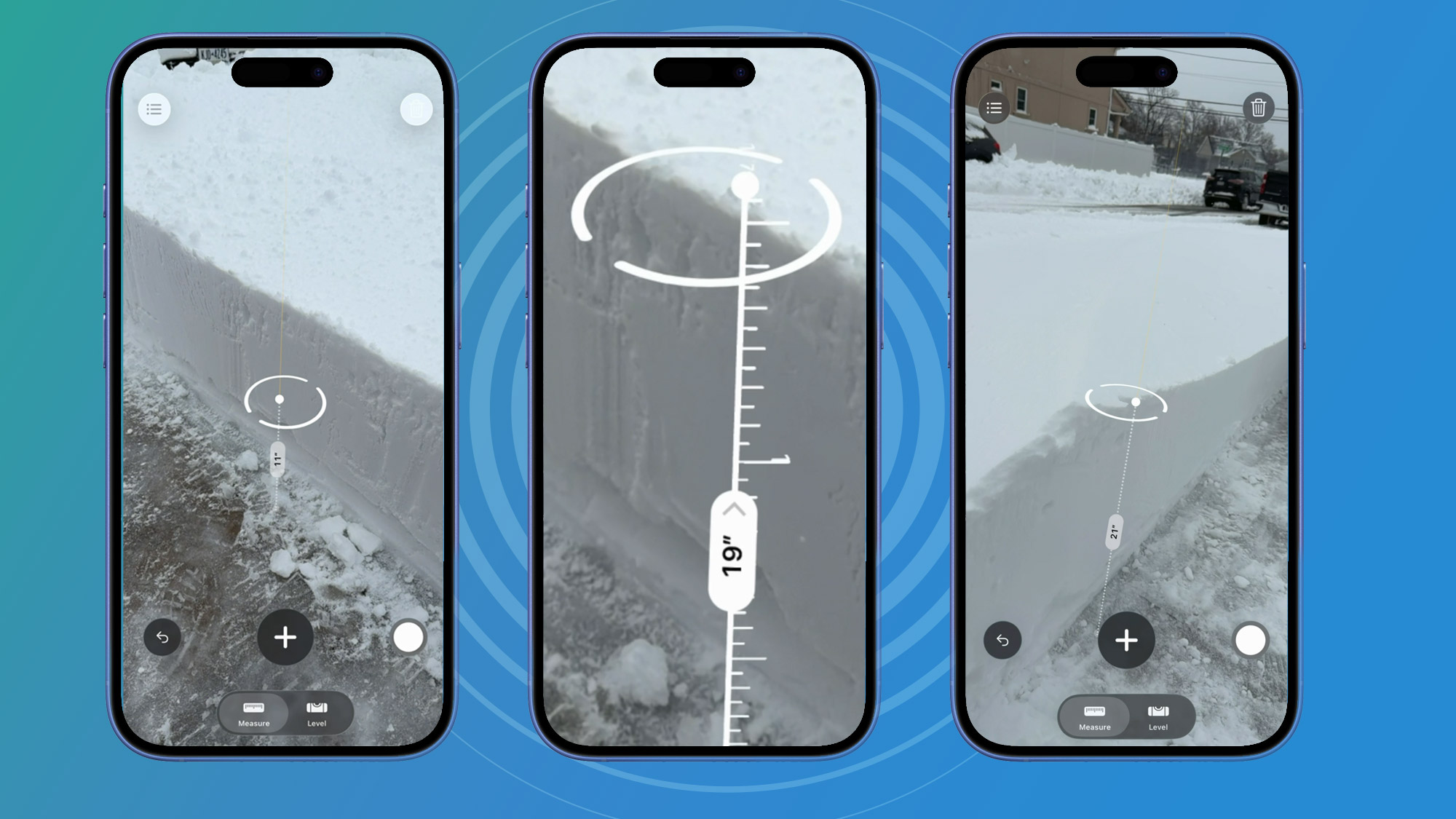
- Point your iPhone camera smoothly toward the measurement surface—here, a clean strip shoveled down to the sidewalk.
- Wait for ground detection; automatic surface recognition locks onto flat planes.
- Tap to set the startpoint at the sidewalk level.
- Gradually tilt the phone upward toward the snow’s peak—a virtual tape rolls onscreen showing the live incrementing height.
- pustsap at the endpoint to capture the reading.
In my case: 19 inches initially, 22 inches at a higher plateau. Simple. Consistent. The AR overlay anchored measurements despite swirling flakes. No specialized training required—just instinctive pointing and tapping.
Why LiDAR Elevates Estimation Games
LiDAR isn’t just for fancy animations. This tech, common in geology and autonomous vehicles, actively scans environments with infrared light pulses. Each pulse’s travel time provides precise depth data—far surpassing camera-faocusbased AR estimation. The Physics World Journal notes that LiDAR’s accuracy diminishes distortions occasionally seen in visual tracking alone:
- Accuracy: Within >±1% for short distances under 10 feet—ideal for snowdrifts.
- Data Fusion: Combines LiDAR point credit clouds with camera imagery for contextual understanding.
- Low-Light Mastery: Performs reliably in poor visibility—like howling blizzards—where cameras alone optic fail.
Think of LiDAR as transforming your phone into a sophisticated rangefinder without bulbs or lenses. Hernandez’s fierce winds felt trivial to the sensor’s computations.
Spillover Applications: Measurement Opportunities Everywhere
Blizzard duty was just starters:
- Furniture Shopping: Spot-check dimensions against doorway openings instantly.
- Renovation Projects: Assess room sizes without unfolding twelve tapes. Capture precise measurements of materials needed.
- Art Placement: Perfectly center pieces on walls using the built-in level.
- Archiving Details: Share room layouts professionally via saved measurements tagged with Notes.
Thousands rely on it daily transforming concepts into plans without physical instrumentation. Its rise parallelscutting-edge featd engineering tools like BIM programs adapting AR tech systematically.
Snow Gives Way to Shared Ingenuity
Standing amidst Hernandez’s pervasive flakes while pulling virtual measurements showcased responsive innovation where consistency mattered most. The iPhone Measure app blended visual sensors and laser inference to offer instant feedback safely replacing avalanche risks for reliable readings proving surprisingly-accurate twenty-inch depths indeed blanketed our region.
So next time unpredictable weather descends—or you’re debating wallpaper dimensions—navigate complexity smarter using tools hiding plainly inside familiar devices bridging gaps between guesswork and gravity-driven numbers miraculously delivered digitally.
Has your smartphone bailed you out unexpectedly? Tell us how@!


